Finding and Exploring Abandoned Rails via Google Earth: Basic Tips

I’ve logged countless hours on Google Earth searching for and following abandoned railroads all across the country. For those who don’t mind losing many hours of spare time, it can be a fun and rewarding endeavour for history and rail buffs interested in such a facet of industrial archaeology. I’m sure it doesn’t give quite the thrill of urban exploration or jungle bushwhacking, but nevertheless it’s a very interesting hobby one can pursue from the comfort of one’s computer chair without any real risk or cost.

First things first, one would probably ask, “doesn’t Google Earth already have a railroad layer overlay?” Of course it does, and a very comprehensive one; it’s located under ‘More > Transportation > Rail.’ However, this overlay only covers active and extant railroad lines, or ones abandoned within the last several years that GE has yet to remove from its database. Abandoned railroads are completely unmarked on Google Earth (though OpenStreetmap lists many abandoned lines, apparently) and if one wishes to add them, one must manually do so by tracing them with the path tool or importing someone else’s KML files with abandoned lines marked.

oakmanwye

Active NS (fmr SOU) line through Oakman, AL, is charted on Google Earth, but the abandoned wye at the center of the picture leading to an abandoned SOU branch to Corona Mine is -not- marked on any overlay.

While there are some resources available for those who wish to mark abandoned lines, for the most part it’s up to the user to find and follow abandoned lines. For most railfans, it should be rather easy to pick out the telltale signs of where a line once ran, but for others, particularly those as inexperienced as myself, it is helpful to have a few tips on how to locate abandoned lines in the overhead view that Google Earth offers.

For this short little article, I will mostly be using screenshots from abandoned lines in Alabama, my home state, as I’ve spent more time looking up things here than anywhere else. Most of these tips should be relevant no matter where the line you’re searching for is located.

First off, one should get used to using the Historical Imagery timeline slider, located on the toolbar. Reason being, while very recent images are usually of extremely high resolution – making the search for basically anything that much easier – the older images are not only closer to the date of abandonment (and therefore the landscape hasn’t been altered by time or development as much) but, generally being without color and in much lower resolution, also tend to be at a level of contrast that makes linear features such as rail ROWs stand out more.

greensboro

Abandoned SOU line through Greensboro, AL. Images from 1992 and 2013; the ROW is much easier to pick out in the older image, as time has worn away some evidence in the 21 years between shots. The ROW is still very clear outside of town in the 2013 shot, though, so this is not always a perfect method of making ROWs easier to locate.

Another good layer to have on is the ‘Photos’ layer, from the sidebar. Many abandoned ROWs have photos along their length, generally posted to Panoramio then selected for Google Earth. If you’re following a linear feature and there are photos indicated along the length, check them out, and you stand a decent shot of the photos being of the abandoned rail ROW or an associated railroad feature that help confirm the presence of an abandoned line. Similarly, check to see if Street View is available for any roads that a possible ROW crosses.

statest-slsf-sumiton

Abandoned DeBardeleben Branch of SLSF crossed the road in Sumiton, AL; Street View helps confirm the existence of the ROW, as seen from the bottom left to the upper right-center. Subtle features, such as the tiny still-extant drainage ditch crossing under the ROW, can help confirm that this is an abandoned rail line as opposed to a power line cut or private driveway (which would typically be much narrower or use a more traditional culvert as opposed to this feature)

Before starting the quest for specific abandoned lines, one should obviously have some general idea of where the line that they wish to track was located. If one knows the name of one or more towns that the line ran through, for example, the search can be started in that town, or if the abandoned segment in question branched off a mainline in a certain county, one can look for evidence of said branch along the GE rail overlay in said county. That said, it’s certainly possible to search for abandoned lines quite randomly, with no particular intent, and hope to find evidence of abandoned trackage along existing lines. This does sometimes yield interesting results.

jasperfeed

Unmarked short spur in 1999 imagery to a now-demolished feed mill in Jasper, AL; location now bears no evidence of rails branching off the main NS line here. Evidence of short industrial or agricultural spurs like this can be found frequently while searching historical imagery along existing lines.

Another important tip to consider, whether searching for an existing line or looking randomly for abandoned lines across the landscape: Follow water! Though railroads try to cross water as little as possible to avoid having to build expensive bridges, sometimes water crossings are necessary, and often bridge piers (or, if you’re lucky, extant abandoned bridges!) are the only remaining evidence of a rail line through a particular area. Bridge piers stand out in aerial imagery, even if the ROW is not visible on adjacent shores, and, if you’re browsing with the ‘Photos’ layer on, there will often be photographs of the piers, as such features are popular photograph subjects even to the non-railfan. One may also find abandoned road bridges by searching waterways, but at least in my opinion, such finds are worth the effort even if they don’t relate to railroad activity.

marveltrestle

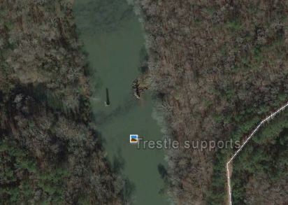
These bridge piers, dating to the late 1890s and abandoned by the 1930s, provide the only remaining evidence whatsoever of the old SOU branch to Masena, AL, from the now-abandoned connection to the main in Marvel. Discovered only by random searching of waterways, and confirmed by the associated photograph, I was able to find out a lot of fascinating information on a long-forgotten turn of the century coal hauling branch that once ran through this area that I had even no vague idea of having ever existed.

Another way – which would seem fairly obvious – to locate abandoned lines is to note where existing rails on the Google Earth overlay end, and visually check to see if there is abandoned ROW beyond that point. This is frequently the case.

lnetowahaband

Old L&N line from Attalla, AL to Birmingham is abandoned beyond a Tyson Foods facility near Ivalee, and thus the overlay ends here; however, the ROW very clearly continues SW, where it will pass through Tumlin Gap and Oneonta on its way to connecting with a former L&N main in Birmingham.

When checking towns and cities to locate abandoned lines, it’s often easy to pick out where the ROW runs by noting the alignment and arrangement of roads. To minimize the number of grade crossings that would have to be maintained and safety-fitted, there will be a gap in roads with only a few crossings where a railroad crosses through a populated area. This is often still evident many decades later, and to make things even easier, many roads which run parallel to a rail line – or are built over a ROW – are named ‘Railroad Street’ (or road, avenue, etc.) or, sometimes, a name befitting associated railroad infrastructure (Station Street, for instance)

hartfordCG

Abandoned Central of Georgia line through Hartford, AL. Note Railroad Avenue, built alongside ROW. The ROW can be easily traced by following the gap in roads from NW to SE in this image.

Also, by use of the photo layer, one can often find old depots, which are popular photograph subjects.

depot

Old Elkmont, AL, L&N depot. ROW here is marked by the light grey line of the hiking trail built on the railbed, and a closer zoom will show that the depot is on Railroad Street. Thus, the signs of a ROW here are unmistakable.

In more rural areas, the visibility of an old ROW in aerial imagery is frequently determined by the character of the landscape it crosses and the length of time that has passed since abandonment. Relatively recent abandonments in rural areas are often very easy to follow.

icatwoodvina

Abandoned Illinois Central segment from Red Bay to Haleyville AL is easily visible between Atwood and Vina, AL, by means of the line of trees growing along the edges of the ROW. Even in forested areas, the nature of the line is different from the surrounding woods and remains obvious. The line was abandoned in 1992, a rather recent abandonment.

Older abandonments, and ones which run through farmland (which is typically reclaimed immediately after abandonment and most traces of the ROW are quickly lost) are harder to pick out, but can still be traced in many cases through use of the historical imagery slider.

cnwpilger

Abandoned C&NW ROW a few miles SW of Pilger, Nebraska, is visible in historical imagery running from bottom left to top right. Paths in farmland tend to be much more faint, as there are often no trees on the ROW to mark the line, and the grade has been leveled in order to facilitate easier farming. The transient nature of the typical farmland landscape, with changes in crops and land use, accelerates the masking of railroad remnants. Still, the ROW is still faintly visible even today, as the ballast from the ROW and the stubborn remnants of the grade still provide a light linear mark on the landscape.

Some ROW is turned over for usage in rail-to-trail conversion, and the roads and trails that this creates are frequently marked on Google Earth. One only needs to follow the marked path to trace much of the abandoned ROW, though the trail may deviate from the ROW or follow only a small segment of the rail route.

vacreeper

The Virginia Creeper Trail, built on the Virginia-Carolina Railway ROW, is clearly marked here at its northernmost point in Abingdon, VA.

When roads are built over railroad ROW’s, it is often exceptionally difficult to actually confirm the whole length of such re-use, as grading and paving has removed evidence of the rails that once laid there. However, it is sometimes possible to make a fairly valid guess, based on the curvature of the road and its location relative to other roads in the area. The road will have wide curves and lay fairly level, often parallel to other roads or otherwise located in a manner which is more typical for rails than a road. This type of situation calls for more research than can be ascertained by aerial images only.

tafttn

Old Railroad Bed Rd in Taft, TN, follows the old NC&StL ROW to Capshaw, AL, removed and turned into a road in the 1930s. The gentle curvature of the road is one of the few indicators that this was once a rail line.

It IS sometimes possible to see where the ROW and the paved roads separate, often depending on topography or population.

tfrwileyga

Old Tallulah Falls Rwy ROW diverges from the highway built atop parts of its roadbed near Wiley, GA. The ROW is under the highway for much of its length north of this point.

If a road has not been re-profiled or changed significantly since abandonment, there will often be bridges over deep cuts that can’t be explained by natural topography (bridges not over water where there seems to be no reason for a bridge, or a bridge where one might suspect a grading fill would be more appropriate) Occasionally, this can indicate a railway once laid under the road, crossed by the bridge.

tessner

Bridge in Tessner, AL, over a deep cut that abandoned Illinois Central ROW runs through. The ROW here is obvious, but had the ROW not run through here, there would be no need for a bridge.

Where a railroad runs (or ran) through very steep topography, the ROW tends to follow waterways, which may be the only relatively level and therefore reasonably gradable land for many miles. Look for signs of possible ROW along such features in areas known to contain abandoned rails. There may also be remnants of bridges crossing the water, then rails continuing on the other side of the water.

saldrige

Former SOU branch from Parrish to Gorgas, AL, winds along a waterway here. Two wooden trestles are apparent on the left, and a very visible fill can be seen to the bottom right.

While bridges or bridge remnants are not always evident, where rails crossed stagnant water or large bodies of water, remnants of a causeway are often visible for a very long time.

swchssc

Abandoned ROW on the SW side of Charleston, SC is very visible, with the causeway built to carry the rails over the large area of water still present.

When following linear features not marked as roads or railroads, it’s occasionally difficult to determine what is a power line cut and what is an abandoned ROW. This is rarely an issue though, as power line cuts tend to be much wider and much straighter, and when they deviate from straight, they usually change direction sharply at an angle. ROWs curve much more gradually and are much narrower.

caincreekln

Abandoned L&N Cain Creek Branch near Sayre, AL, crossing a power line cut. Power line cut is much wider and much straighter.

More will be added to this article as I think of more things to add!


A few helpful references for abandoned lines:

Abandoned Rails

SPV Rail atlases

The Orphan: Illinois Central Brilliant Branch

THE ORPHAN

Until the latter part of the 20th century, an enigmatic and nearly forgotten rail line snaked for several miles through the quiet backwoods of southern Marion County, Alabama, isolated from its owner’s main line by dozens of miles. It was a small part of an ambitious plan that never came to be, a small reminder of a route that was never actually laid. But most of all, it was a fascinating and essential icon of the history of this area, the lifeblood of a town that still bears the name of the mine that helped it grow and thrive.

The story of this railroad begins in the 1880s, in Mississippi. The Canton, Aberdeen & Nashville was incorporated, as a subsidiary of Illinois Central, in February of 1882 with plans to connect with Nashville through central and north Alabama from its terminus in Mississippi. The route was completed to Aberdeen in 1888, when the ambitious plans cooled somewhat without a connection to Alabama.

When a very high quality coal seam was discovered north of Winfield, Alabama, and a mine built to serve it by the early 1890s, Illinois Central decided to act further upon its ambitious Canton, Aberdeen & Nashville project and tap into the rich coal resources in Alabama. Initially it was planned to build a line from the main near Aberdeen to this mine, by way of a line through Vernon and Winfield, but eventually IC negotiated with Kansas City, Memphis & Birmingham (soon to be fully absorbed into SLSF, better known as the Frisco) for some level of trackage rights on their line from Winfield to Aberdeen, requiring only the construction of a line from Winfield north to the mine at Brilliant. Some grading work was apparently done near Vernon in anticipation for the construction of the CA&N line through this area, but rails were never laid on this grade as trackage rights fulfilled the needs of Illinois Central’s isolated branch.

The Brilliant Branch opened to traffic in June of 1899, though some sources state 1898. It was officially designated the Winfield District by the IC. Brilliant Coal Company operated a profitable coal mine near the town of Boston (which would eventually become Brilliant) and the rails ended in the valley where the town of Brilliant was beginning to grow just outside the mine. A station was constructed and traffic began to run on this line, extending from the mines to the interchange with KCM&B at Winfield, 10 miles to the south. It is not entirely certain whether IC was allowed to operate from Winfield to their connection near Aberdeen on KCM&B/SLSF tracks, or if a locomotive in captive service on the Brilliant branch line had to shift its cargo to a KCM&B/SLSF train to reach IC’s main. Most sources suggest the latter.

The project involving the connection to Nashville using this branch as a launching pad, per se, was not forgotten. In 1903, these plans were still being considered. IC had built south from Nashville and had surveyed all the way to Tuscumbia, AL, in preparation for eventually connecting the Brilliant branch to points north, running through Double Springs, Decatur, and Tuscumbia to eventually connect with IC’s lines in northeast MS and southern TN. The charter for the CA&N regarding this line a few years prior provided for this extension, expecting the Brilliant branch to be only the beginning of the line’s march northeast further into Alabama. However, the coal reserves that IC hoped to tap on this line proved to be far less extensive than they had initially expected, and the plans to extend this line from Brilliant were shelved.

The little line from Winfield to Brilliant thus eventually wound up as the only section of the CA&N/IC-planned route through Alabama that was ever constructed. Its utter isolation from IC’s other routes earned it the nickname ‘The Orphan’, and the branch continued in operation with little change for the next few decades, primarily serving the Brilliant Coal Co. mine and a few other much smaller operations. The entire town of Brilliant moved uphill by the late 1920s, as detailed in the town’s history at the end of this article, but the Brilliant Branch still operated, the very minor revenue from passengers after the station was relocated apparently not being missed. The high quality coal from the seam was used to fuel some of IC’s locomotives in the region, in addition to the revenue from the transport of this coal elsewhere, making the branch fairly important to IC’s operations in the southern states.

Operations on the branch were fairly simple. According to records from 1950, a daily freight served two mines on the branch. Coal was accessed by an electrified drift type mining operation, cutting into the hillside to reach the thin but rich low-ash seam of coal. A low-drivered 4-6-2 steam engine was used on the line, kept at the Winfield terminus when not in use. The locomotive did not rack up an impressive mileage count on this line, traveling on average only about 20 miles per day, the distance from the Brilliant mines to Winfield. Most sources indicate the from the interchange here with the SLSF to Mississippi was accomplished with the SLSF’s own locomotives. The SLSF had to accommodate the movement of the IC’s locomotive when maintenance was necessary. It’s worth noting, though perhaps on an unrelated note, that Illinois Central was one of the last Class 1 railroads of the era to fully dieselize.

Things were to change significantly as the 1950s carried on. Brilliant Coal Company ended its Brilliant operation during this period, taking with it the primary source of revenue for the railroad branch. In July of 1954, IC sold the Brilliant Branch to SLSF, the company that had transported coal from the mine on its own tracks for half a century. This sale left the Corinth to Haleyville branch the only IC property in north Alabama. But despite the closing of the productive mine at Brilliant (or, perhaps, operation under a different company on a smaller scale) the new owners did not abandon this branch. Enough mining still existed on the short branch that SLSF continued to ship coal out of the mines that remained for many years. This was perhaps even more easily done now that the SLSF owned the branch and there was no longer an interchange between two different railroads that had to be consummated in Winfield.

Incredibly, despite the upheavals and abandonments that punctuated the railroad newswires through the 60s and 70s, the branch continued to operate under the SLSF into the modern era. According to some who actually worked on this branch during the later SLSF years, the branch was in fairly poor condition, and significant speed restrictions were in place. A single road engine would slowly ply its way to the mines to pick up a string of coal hoppers from the mines a few times a week, leaving the cars in Winfield to be picked up by a northbound freight. The line had clearly seen far better days, and it wouldn’t have surprised many if the announcement came that abandonment would soon be upon the Brilliant Branch.

And so it was. By the time the SLSF was absorbed by Burlington Northern in 1980, the line was in little use. With little fanfare, in 1983 the Brilliant Branch was formally abandoned, and shortly thereafter, the rails were removed along the entire route, including the road grade crossings. The only possible exceptions to this were the left leg of the wye interchange with the BN (now BNSF) in Winfield and perhaps one or two of the small trestles over the creek that the route crossed multiple times on its way to Brilliant.

The lot that contained the southern terminus of the Brilliant Branch in Winfield, according to reports, became the home of a wood yard briefly, with either the left leg or the wye or a new, straightened spur built by BN used as a loading spot for pulpwood through the 1990s. This spur, and the associated wood yard, was abandoned sometime around 2000. The line through Winfield is now controlled by BNSF, with little trace of the IC branch that led to the mines at Brilliant. However, the original CA&N/IC station, constructed in 1898, still exists in a small park on the northern edge of Brilliant. It was moved there more than 70 years ago when the town relocated and now houses a small mining museum.


THE REMNANTS TODAY: THE ROUTE MAP

A few weeks ago, I went to Winfield to try to find evidence of where the line once lay. Using Google Earth and historical maps, it was possible to trace out the entire route. This is laid out in the associated zip file, which can be loaded in Google Earth with waypoints and photos  throughout.

The line began at the wye in Winfield, between modern AL 118 and the BNSF mainline, south of Apache Street. This lot contained the wye and later a wood lot and a BNSF spur, today containing just the abandoned spur. There are few traces of the original wye that led to Brilliant at this location, but still a lot of interesting railroad history here.

DSC07569

Looking SW from the ‘modern’ abandoned spur that once led to the wood lot in Winfield. The Brilliant Branch connected with what was once the SLSF (now BNSF) here, where the more modern abandoned spur now juts out into the seemingly abandoned lot from the BNSF main. It appears as though the switch has been removed and there is no longer traffic on the spur on this historic lot. The BNSF mainline in the background, though, is still very much in use.

DSC07567

Looking NE on the abandoned spur in Winfield. The wood yard once stood here. The Brilliant Branch wye’s right leg curved around the trees in the background. The BNSF main is to the right, and downtown Winfield – along with where the right leg connected with the left to form the Brilliant branch line – is to the left.

DSC07570

On the abandoned spur in Winfield, near the old BNSF junction, looking NE. According to old aerials, the left leg of the Brilliant Branch wye curved around the trees on the left side of the picture, to the left of the modern spur, and connected with the right leg – which curves around the trees just above center in the photo – near the left edge of the picture just south of the interstate. Note apparently abandoned building still extant on the track of the left leg.

DSC07555

Looking SW in Winfield towards the ‘modern’ abandoned spur. The left leg of the Brilliant Branch wye curved around the trees in the center of the picture, passing beside the building at right center and exiting the picture to the right. Note remaining structures and artifacts, from either the railroad or the wood yard. Any insight on these remnants is welcomed.

DSC07575

On the lot in Winfield, looking north. The legs of the Brilliant Branch wye connected near the center of the photo, crossing the highway (also seen at center) almost immediately, then continuing north toward Brilliant to the left of the tanks seen on the right side of the photo.

DSC07560

Abandoned spur in Winfield, looking SW toward the former junction with the BNSF main. The Brilliant Branch wye’s left leg curved around the right side of the picture.

DSC07556

The switch from the modern spur to the BNSF main – or possibly the Brilliant branch wye – was removed, but parts find new use at the edge of a parking lot. This is on the property just to the west of the lot where the wye once was.

The wye formed the edge of the lot, still visible in the arrangement of mature trees north of the BNSF main here. The wye legs connected to form the single-track Brilliant Branch just south of AL 118, which was the first road crossing on the branch’s route northward. From AL 118, the line moved just east of due north across a lot between buildings to a grade crossing on Apple Avenue.

DSC07537

On Apple Avenue in Winfield, looking south. The photo location is very near where the former grade crossing was on the Brilliant branch. The line passed north from the highway just right of the center of the picture, through the grassy lot near the center, and crossed Apple Avenue near the bottom left of the photo. Note wood in the lot – former railroad ties?

From the Apple Avenue crossing, the line continued nearly due north along what is now Community Street. The rails once laid where this road is now; indeed, Community Street was laid over the abandoned railbed. Note that there are two parallel roads labeled Community Street; the one to the west – left if facing north – is where the rail line was. My guess is that the railbed was paved over to provide better access to the school and relieve congested traffic near the core of the quickly growing town.

DSC07534

On Apple Avenue, at former grade crossing, looking north. The railbed has been paved over by the road in focus, now Community Street, providing a perfect record of where the Brilliant branch passed through. The line is located where the road is now, from bottom right to above and left of center.

The rail line continued north under what is now (the left alignment of) Community Street, just to the east of Winfield City Middle School, crossing what is now Anchor Drive. Another crossing follows on Cemetery Street, where the north-south road paved over the railbed shifts and the railbed becomes part of a paved walkway connecting the middle school and the elementary school just west of Park Drive.

The next four-way is at at Berkley Avenue, when Park Drive turns right and the north-south road becomes Community Street once more. It should be noted that these roads are relatively new; in the heyday of the Brilliant Branch before the 1970s, there were no major road crossings between Cemetery Street and CR 14.

Community Street veers into CR 14 shortly thereafter. North of the street, and parallel to CR 14, the railbed is fairly easy to follow on Google Earth as it veers NE, through what today is woodland, curving north to cross CR 14 just east of its junction with CR 47.

North of this crossing, there is a private road blocked off by a gate that utilizes the old railbed through young second-growth trees as the former line moves nearly due north; this should be easily picked out from the ground if the landscape doesn’t drastically change soon. This trail is easy to pick out from the air as it leads through fields and young timber east of CR 47 for about half a mile before the route made its first crossing of a branch of Luxapalilla Creek. A small trestle existed here, or may still possibly exist in dilapidated condition.

The rail line curves NE from this crossing, forming the border between forest and field, still clearly defined as a rural trail on private property. Aerials indicate hay bales or other farm items stored on the railbed here. The line then crosses CR 173 at a kink in that road, a decent visual clue.

The rails made their second crossing of the branch of Luxapalilla Creek just north of the CR 173 crossing. The ROW then winds NE then eventually N through what is now second growth forest about halfway between and roughly parallel to CR 47 and Riley Harp Rd for about a mile before crossing CR 47. The ROW is a farm road here to the south, and visible in the gap of slightly younger trees in the forest to the north, next to a power line cut. The road seems to have been recently repaved here.

The rails continue due north (with a slight left bend about midway, returning then to due north) through woodland for about 1.5 miles between the crossing and new US 78, crossing the branch of Luxapalilla Creek a remarkable three times in only half a mile. The rails thus do not necessarily follow the lay of the land here, probably built up on slight fills and cuts and crossing the creek more times than would be usual to allow for a level, due north route instead of following the sinuous creek.

The railbed where US 78 is now is very hard to decipher from the ground, as construction has obliterated most of it, but could possibly be seen to the south as a gap between larger trees. The Brilliant branch crossed the site of modern US 78 at nearly a right angle, then curved NE north of the site of the highway.

The railbed is nearly impossible to follow in this day and age for about 1.7 miles to the northeast, as heavy logging and, probably, surface mining operations have erased the former grade nearly completely. The rails crossed what’s now CR68 and continued NE then NNE through rough terrain before becoming visible again just south of AL 44 in the Pull Tight community.

The rails crossed AL 44 in a still-visible gap in the trees half a mile west of AL 44’s junction with AL 129. Once across the road, the ROW veers sharply east-southeast to parallel AL 44 to its junction with AL 129, about where the western edge of the ‘old’ town of Brilliant was before it was moved uphill and north.

It’s worth noting that aerial imagery revealed the presence of a turning wye in roughly the same alignment as the junction with AL 44, AL 129, and Main Street; this, I assume, was used to turn the locomotives for their trip back to the Winfield interchange. This turning wye appears to have been abandoned quite a few years before the rest of the line, and there seems to be little if any evidence of its presence today. It is located just above where Main Street splits to merge into AL 44 and AL 129. There may still be a slight gap in the trees today.

The line then crossed Main Street right after the wye and turned more southeasterly into what was once Brilliant, where the station was located. The line then continued through the valley that old Brilliant was built in and curved to the south to reach the mines that inspired the construction of the line, the rich Black Creek Seam. The line’s distance past the wye was somewhere around two miles to its terminus, probably slightly less. The extension northeast to Double Springs and Decatur from here never happened, though there may have been grading done. The ROW through the valley where old town Brilliant stood is somewhat difficult to pick out from aerial imagery, but may still be visible from the ground, along with artifacts from the town that sprang up in this valley over a century ago. This valley is abandoned today, home again only to the forest and the creatures that called it home, as it was before the iron horse first pulled into the Brilliant station more than a century ago.

DSC07511

Original CA&N/IC depot, built in 1898 in ‘old’ Brilliant on the Brilliant branch and moved up the hill to its present site c. 1920s. Today it’s home to a mining museum. It sits more than a mile from the line it once served, and at around 80′ higher elevation!

BRILLIANT, ALABAMA

Brilliant, Alabama is a small town located in rural Marion County, several miles north of Winfield. Its history is rich, and its story is one of changes – of names, of economic forces, and even of physical location.

700px-Marion_County_Alabama_Incorporated_and_Unincorporated_areas_Brilliant_Highlighted.svg

The story of the town begins in the late 19th century, when the town of Boston was incorporated, named for the Bostick family. The Aldrige brothers operated the Aldrige Mining Company just south of town, which became the Brilliant Coal Company before the turn of the century when it was sold to Birmingham investors. This mine would become the catalyst for the growth of the area and the rail line that once led to the community.

What, though, does the town of Boston have to do with the article, and how did the name Brilliant originate? An interesting series of events in the early part of the 20th century provides the answers to both. The original town that became Brilliant was located at the bottom of a hill, where the rail line ran to the mine. When the mine shifted location, and the post office moved to the top of the hill in Boston, the name of that community was changed from Boston to Brilliant both because there was already a Boston post office in the state and in order to honor the coal company that brought economic development to the area. The name Brilliant was given to the original mine because of the quality of the coal produced – the low ash and sulfur coal had a brilliant glossy appearance. The seam, known as the Black Creek seam, is said to have produced some of the highest quality coal available in the country at the time.

A map of the Brilliant Branch and associated placemarks has been created and made available for download. Check back for updates and corrections on the map and the article.

http://www.mediafire.com/download/jc7t7c1ll3bg1ep/The+Orphan+%5BIC+Brilliant+Branch%5D.zip

This article is a work in progress, and further information, corrections, or any insight would be greatly appreciated.

SOURCES, REFERENCES, AND FURTHER READING

CA&N

CA&N Charter

Brilliant Coal Co advertisement

Brilliant history

Financial report from 1903

CA&N Charter

Brilliant Branch extension plans

More extension details

Charter

Extremely informative thread on Frisco discussion forums

Photo of Frisco locomotive in Winfield

Route information

The Great Lost Brushy Creek Trestle

In the annals of railroading history, there have been a great many imposing structures built to carry the rails across valleys, waterways, or roads. Viaducts, trestles, bridges – whatever variety or construction, the awe-inspiring mountains of metal (or wood, even) have supported many decades of history, and provided railroad and architecture enthusiasts with a magnificent spectacle to marvel upon.

As the industrial age gave way to more modern times, so too did the classic days of railroading evolve. With the passage of time, many of these grand architectural landmarks became derelict, and even those in use began to fall into some level of disrepair. A great many have been scrapped, many more are abandoned and rusting away on some forgotten rail line in the middle of nowhere, and a handful of survivors hang on with intensive maintenance, still used to carry freight or passengers as they did many decades ago. Those that remain are quite an impressive sight, especially those which are still in service; there are few things more impressive than watching a freight train cross a classic historic viaduct.

Sadly, even those that have survived into relatively modern times have suffered significantly – even those that are protected or maintained. Perhaps most poignantly, the great Kinzua Viaduct in Pennsylvania, spanning nearly a half mile over Kinzua Creek 300 feet below, was devastated by a 2003 tornado that brought down more than half its great spans. Still many others have been torn down due to liability, negligence, or for being largely obsolete for their original purpose.

Such a fate befell the great Brushy Creek Trestle in October 1996. Though mostly forgotten and hardly a reference is to be found, memories of the imposing trestle are still very much alive to long-time residents. Trips to see the viaduct were apparently rather common, and many recall walking on the trestle, staring at the creek 187 feet below.

Brushy Creek is a narrow, winding waterway located roughly halfway between Hackleburg and Haleyville in Marion County, Alabama. This region, at the southern tip of the Appalachians, has a long rail history dating back well into the 19th century. In 1901, Illinois Central began to scout for a location to construct a line to Birmingham, AL. Investigation of the terrain and the existing routes revealed that the most efficient location for this new line would be through this area, between Jackson, TN, and Jasper, AL. After a brief setback, trackage rights from Haleyville to Birmingham were acquired to connect the incipient line to its goal, and construction began. It was noted that Brushy Creek, and the deep gorge it carved into the landscape, would require the railroad to either route around or build a viaduct to allow trains to cross the obstacle. After a thorough study, the latter option prevailed.

rrg1

The construction detail of the bridge, taken from an old Railroad Gazette article (viewable in Google Books) reads thus:

Total length, face to face of parapets: 1,230ft 7 1/4 in
Maximum height, base of rail to masonry: 171ft 2in
Total weight of structure: 1,943 tons
Total amount of masonry: 1,550 yds

“Ten 75-foot plate girder spans, nine towers with 40-foot deck plate girders, and two 60-foot deck plate girder approaches. The 60-foot approach spans rest on concrete abutments and rocker bents. The towers and rocker bents rest on masonry piers on solid rock foundations. The tops of the piers are all 5 ft 6 in square, varying from 6 to 24 ft in depth, according to conditions. The masonry piers are all stepped on the outside to permit future extensions to the masonry for a second track. The tower spans are fixed at both ends on the columns and the 75-ft spans on each side are alternately loose and fixed at the ends. The towers themselves are fixed at diagonally opposite corners of the bases, expansion being provided for at the other corners. Each of the towers consists of four columns joined by diagonal braces of channels. Each column is made up of two plates and four angles. Two angles are riveted to each plate, the two plates being spaced 21 1/4 in. and laced with 3-in. x 3/8(?) in. angles. The towers are built in one, two, or three sections, according to height. The top sections, the middle sections, and the base sections, respectively, for all towers, are built of similar elements. The steel for the viaduct was furnished by the McClintic-Marshall Construction Co., Pittsburgh, Pa. It was erected by the Strobel Steel Construction Co., Chicago, with a double trolley traveller, as shown in one of the photographs herewith. The total time from beginning the work of erection until trains were allowed to cross the viaduct was 40 days.”

The trestle went into service in early 1908. The route on which the trestle was built was the major carrier of rail traffic between Haleyville, AL and Corinth, MS. The line also carried passenger trains, primarily travelers from Miami to Chicago – most famously, Illinois Central’s legendary City of Miami streamliner crossed the bridge, undoubtedly offering a breathtaking view from high above as it raced across. In addition, a one-coach train known as the Doodle Bug shuttled passengers between Hackleburg and nearby towns, offering an inexpensive and useful method of transportation for locals. It was certainly a bustling center of activity for a good while in rural northern Marion county.

rrg2

The trestle quickly piqued the interest of local residents, and held it for generations. A handful of legends and stories surrounded the viaduct. Most notable, perhaps, is the story of one Rube Burr, an outlaw that is said to have robbed trains going through the area, presumably as they slowed in order to safely cross the viaduct. A cave near the trestle is said to have been his hideout. Whether this is local legend or fact is not certain, but records note that the outlaw probably died before the trestle was constructed. Adding to the mystique that the structure developed, three people are known to have died on the bridge – two during the construction, and another man whilst painting the trestle in 1939.

Looking across viaduct in 1983

1983 view across bridge; courtesy of Bernie Feltman

The Doodle Bug ran its last in 1941, and passenger service was discontinued altogether on May 2, 1971, when Illinois Central ended passenger service at the dawn of Amtrak. The route was relegated to carrying freight only for the next two decades. The aging trestle stood firmly and quietly in its heavily forested ravine through the 1970s and early 1980s, showing its age more and more with each passing year as the massive structure rusted in the damp Alabama backwoods. Freight traffic still passed over it, though not as heavily as before. However, change was rapidly approaching. In 1988, Norfolk Southern purchased 377 miles of lines from Illinois Central as the railroad sold off a massive swath of east-west lines, including the portion that contained the Brushy Creek Trestle. Norfolk Southern never actually used this part of the line, citing lack of profit, and the last train crossed the viaduct sometime in 1988. The viaduct was in limbo, of sorts, until 1992, when Norfolk Southern successfully petitioned for the right to permanently abandon this section of railway, along which the viaduct was located.

Brushy Creek Viaduct

1983 view; courtesy of Bernie Feltman

The viaduct, a massive rusting relic of a lost age, was left standing, prompting at least one local historical society to consider purchasing the neglected structure as an important piece of Marion County and southern railroading’s history. However, tragedy struck on September 14th 1993. 14-year-old Eric Ricketts was trespassing on the viaduct with a friend, riding an ATV. At one point along the bridge the ATV became stuck, and in the process of dislodging it he fell off the bridge, 160 feet to the valley below. Remarkably, he survived, but suffered serious and debilitating injuries. Naturally, the father sued the railroad, culminating in a two-year court situation.

This incident was a heavy determining factor into the then-obvious yet unfortunate conclusion that the derelict bridge was a liability, and with the closure of the line, there was no safe reason for the structure to remain standing, despite its historical significance. In late 1996, the Brushy Creek Viaduct was torn down, taking with it nearly a century of memories and railroad history.

Today the site is home to a young second growth forest, and it seems as though the area is now hardly discernible as having been part of a rail line. A diffuse ridge where the track for the line once laid is faintly visible on aerial imagery of the area, but virtually all traces of the railway are already gone. The earliest Google Earth shot available, from 1999, shows the remnants of the foundation and a heavily disturbed area surrounding the bridge, where material and machinery were hauled in and out. More recently, fewer and fewer artifacts remain, and it seems as though nature will soon fully reclaim the creek bed where the Brushy Creek Trestle stood for 89 years.

Date nail

Date nail in cross tie, 1983; courtesy Bernie Feltman

While the demise of this historic viaduct is disheartening, it should serve as a stark reminder that we need to work to preserve the structures we have left while remaining mindful of the bridges lost to time and apathy. The Brushy Creek trestle should have been preserved, it could be argued, and perhaps restored as a part of local history, but extensive efforts to prevent trespassing, vandalism, and other issues regarding liability would have required enacting – a task that was not organised quickly enough to save the engineering masterpiece. But there’s little use dwelling too heavily on a trestle gone for 17 years when there are equally historic bridges at risk of demolition at this very moment. It’s a tough road ahead, but a road we should travel in order to document and protect the last vestiges of America’s past as told by these historic structures.

The above is an essay I wrote for BridgeHunter.com.

Poking through old newspaper and book archives on Google, I found multiple articles about the trestle, along with multiple photographs. These are posted below.

Railroad Gazette, 1908

Railroad Gazette, 1908

Railroad Gazette, 1908

Railroad Gazette, 1908

Railroad Gazette, 1908

Railroad Gazette, 1908

Railroad Gazette, 1908

Railroad Gazette, 1908

Railroad Gazette, 1908

Railroad Gazette, 1908

The Railway Age, 1907

The Railway Age, 1907

The Railway Age, 1907

The Railway Age, 1907

The Railway Age, 1907

The Railway Age, 1907

The Railway Age, 1907

Article on the demolition

Accident that led to lawsuit

Accident that led to lawsuit

References:

Times-Daily, Oct 21 1996 “It’s History” – Article on the demolition of the viaduct

Court Case – Details of the 1995 court case regarding the teenager that fell off the trestle

Extensive construction notes and photograph – Google Books link

More extensive details – Google Books link

Message board discussion – Mention of viaduct in group discussion

Bernie Feltman

Historic Train Trestles and Viaducts

In the past couple of days, searching for leads on a couple of historic railroad trestles in Alabama, I came to the shocking realisation that there are rather few resources on old rail bridges available. There are several sites for documenting and preserving our historic, irreplaceable road bridges, but often there is only scant information about the rail bridges that have graced the country throughout the last 150 years. And with only a few massive imposing viaducts left, I think it’s rather important to document what we have left – and what we’ve lost – and preserve at least the memories (and the statistics) of our historic trestles and viaducts.

This is kind of a side project of mine. I’ve always liked railroad trestles and viaducts, but only recently has my love for architecture spread into my appreciation of these bridges – and now more so than ever it’s becoming a bit of an obsession. I appreciate every little scrap of information, story, photo, et cetera that anyone can provide; absolutely anything you can do to help with this is graciously appreciated, and with your help, we can develop an online repository strictly regarding rail bridges.

My main areas of interest, and the site focus, are the deck plate girder and wood/steel stringer trestles/viaducts (see Kinzua bridge, Tulip trestle, etc to get an idea of this type of structure) of the Southeastern states, but details of any rail bridge of any type anywhere will be appreciated.